29th July 2019-21st August 2019
Trip Leaders: Phil and Gill
Participants: Paul and Tineke, Mark and Felicity
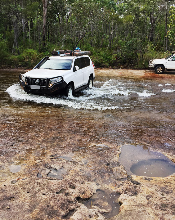
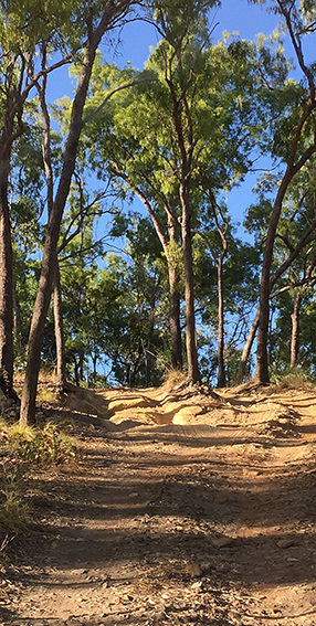
The group met at Wonga Beach Pinnacle Village Caravan Park. Our first day on the trip we left camp early and drove through sugar cane country to the Daintree River ferry. On our way to Cape Tribulation we stopped at Mt Alexandra lookout for a view of the Daintree River valley and Thornton Beach. Morning tea was taken at the Cape Tribulation beach where ‘the rainforest meets the sea’. We watched the orange footed scrub fowls scratching vigorously at their huge nest. Taking the Bloomfield track (CREB track was still closed) we were soon in low range tackling the long steep inclines and declines, some over 10%. We had our first taste of creek crossings too. Lunch was enjoyed in a pebbly creek bed where one of our group enjoyed a swim in the nearby flowing water. Continuing on, we crossed the Bloomfield River then walked in to view the Wujal Wujal Falls. We took a short break at the ionic Lion’s Den Hotel to enjoy a cool drink and a wander through the museum of old memorabilia. The nearby Black Mountain, so named because of the black lichen covering the rocks was an interesting stop. We drove through Cooktown 16 km to reach Endeavour River Escape, our first camp site. This working farm was a gem of a bush camp - great facilities and spacious secluded sites that allowed campfires.
A free day was declared to explore Cooktown so that people could pursue their own interests. At the end of the day it was apparent that many common sights had been enjoyed - the Captain Cook statue and monument, the botanical gardens, nearby Finch Bay, the Grassy Hill and Lookout over the town, river and ocean, The National Trust James Cook Museum, and bird watching at Keating Lagoon.
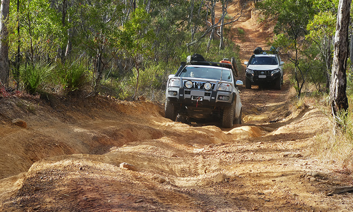
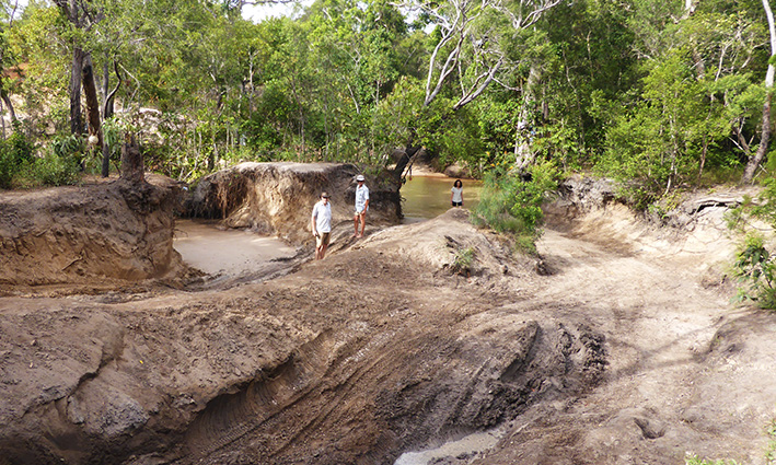
| Our first true 4WD track was the Starcke River Track. It promised to be a long challenging day so an early departure saw us leave Endeavour River Escape by 7:00am. We headed out to Hope Vale community and into Elim Beach to see the coloured sands. ‘Ancient Eddie’, the aboriginal custodian of the area, gave us directions to the colourful high sand dunes. Due to the high tide, we had to gingerly wade through ankle deep crocodile frequented water to see the dunes. Back on the track, we stopped at Isabella Falls for morning tea where we met a fellow traveller who had recent information about the state of the Starcke River track. Surprisingly, we drove through some intensive farmland, with cropping, palm tree farms on rich red soil as we approached Starcke River. The track deteriorated significantly once over the Starcke River, becoming very narrow and littered with many deep washouts and steep dry creek crossings. Just after 2:00pm we arrived at the shallow, sandy bottomed Jeannie River, our first real obstacle! With assistance from the group of 7 cars and a boat trailer that had just spent 4 hours getting over the crossing, we were winched out of the sandy river straight up a massive sandy hill. The usual exit was too badly damaged by previous vehicles to even attempt the 3-4 winch points to get through. Once we had all our cars winched up the hill, we called it a day and set up camp in the bush near the top of Jeannie River. The river provided a refreshing cool off before dinner. | 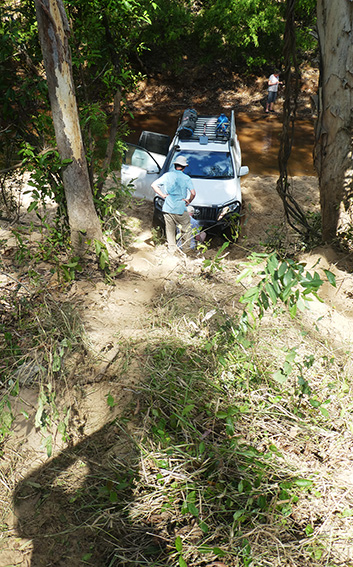 |
Day 2 of the Starcke River track was equally challenging with many deep washouts and jump ups. Howick River had a steep entry and exit and wild pigs fossicking in the muddy water. Many dry creeks were crossed before we finally climbed up Jones Gap where we had a great view of the red sandstone escarpment of the Altanmoui Range, topped with massive hoop pine trees. Approaching the Wakooka homestead we passed by several lagoons with straw necked ibis and again destructive evidence of wild pigs. Little remained of the old homestead but it is a great meeting point of people heading out to Cape Melville. Our ‘information’ told us that this 42 km track had been ‘worked on’ but we saw little evidence of any work. The track was rutted, often very sandy and had many creek crossings (wet and dry).
There was a large swampy area behind the beach which we had to cross in order to access Crocodile Camp where we spent the night. Cape Melville had only just opened but already several fishermen were well set up in the prime camping spots. We found a semi sheltered campsite in the dunes overlooking a small lagoon. A great spot for croc spotting we thought, but to no avail. Walking along the beach and watching the glorious sunset concluded another great day.
The tides were not in our favour to attempt driving to the pearl luggers memorial near the tip of the boulders of Cape Melville so the next morning we retraced our tracks down to the Wakooka homestead ruins then drove on to the Kalpower Crossing where we stopped for lunch and watched several vehicles drive through the deep crocodile infested water. Having washed our vehicles we then proceeded to the Rangers office at Lakefield in search of current information on the state of the Running Creek track. ‘The river at the end of the track is impassable’. So our route for the next day would have to be modified! Heading towards our camp at Hahn Crossing that night, we stopped at the White Lagoon but there were few birds (Red Lagoon was closed), and the ruins of the Brezza homestead which was dominated by a huge old mango tree. We were thankful that the wind subsided as the evening progressed. Camping right beside the river, we watched several boats launch and return with no fish. Freshwater yabbies were being caught in pots.
On the road out of Lakefield National Park we saw many wallabies and grey pointed-topped termite mounds. We met the PDR at the Musgrave Roadhouse where we stopped for morning tea (and real coffee!). As we headed off towards Coen, we had been warned that the PDR would be badly corrugated in sections with a few patches of asphalt. The corrugations were intense. Short of Coen we turned onto the Port Stewart Road to find a lovely camping spot beside the Stewart River. Not even the rain that fell while we were here could dampen our spirits as we all enjoyed a lovely wash in the clean flowing water, one car was even washed! And fruit damper was cooked in the dutch oven on the fire.
Next morning we took the Old Coen Track, a recommended 4WD track into Coen. This track had been graded and is now a good gravel road. After a brief stop in Coen for supplies (and phone range) we were on the PDR. A large section prior to Archer River Roadhouse was having major works done so at times we were following a pilot car through the road works. Heading towards Weipa, we pushed on to the Merluna cattle station where we set up camp and enjoyed a late lunch, free of the dust we had experienced all morning. The lush green grassy camping spots were a lovely treat. A walking track down by the nearby river was a pleasant stroll in the afternoon. A large open shed doubled as a camp kitchen where we enjoyed pancakes cooked by one of our group later in the evening.
After a short drive into Weipa, we stopped at Emberly River for morning tea. Here we could view two large ships being loaded with bauxite. We were then able to get an early check-in at the Weipa Caravan Park where we spent the next three nights. In the afternoon we went on the three and half hour tour of Weipa and the mine. Our guide, Handus, was extremely knowledgeable and presented the story of Weipa in a very interesting and entertaining manner. Accessing the mine roads and seeing the haul trucks up close was impressive. We all agreed that the tour was very worthwhile.
We took a day trip north of Weipa, crossing the huge single lane bridge across the Mission River towards the Andoom Mine. We headed out to the Pennyfather River where we drove to the top of the sand dunes then walked down towards the beach. There were several recently laid nests of turtle eggs. Rangers soon arrived to check that the sticks around the nests were still in place and then drove on down the beach to check for new nests. We then drove through the soft sand dunes to the mouth of the Pennyfather River where we saw many more campers/fishermen. The track back had us driving through low swampy land with melaleucas and lagoons. Back on the main road north we travelled on to Cullen Point where the Wenlock enters the sea. The moving memorials at Old Mapoon told of the mistreatment of the original inhabitants of the area. Then we headed back to Weipa on the good gravel road.
After a well-earned rest day in Weipa to restock the fridges, refuel, top up water, wash clothes etc we headed off a little later than usual to allow some mechanical work to be completed on one of the cars. The shortcut via Batavia Downs was a good gravel road to join up with the PDR which was very corrugated up to Morton Telegraph Station where we stopped for lunch. At Bramwell Roadhouse we stopped for the obligatory photo of the start of the Old Telegraph Track then we pushed on down the narrow track to Palm Creek. We had heard many stories about this crossing and were surprised to find no one there but it was quite late in the day! We inspected all the entry tracks and tried to find the exit. The water was too murky to walk and we could not see the winch point people had spoken of so common sense prevailed and we headed out to the PDR, up to the Bypass road and rejoined the OTT at Bertie Creek. This was a lovely quiet spot to camp and swim.
The next morning we were on the track early and headed south across fast flowing, rock bottomed Bertie Creek, south to Dulhunty for a quick double crossing much to the surprise of the many campers there, then back to Bertie Creek and Cholmondeley Creek then on to Gunshot Creek. After walking the creek we chose the ‘easier’ entry which was still very, very steep into deep water. With a recovery strap attached at the back of the car (in case the car fell in a deep hole and needed to be pulled out) the first car headed into Gunshot and successful drove right through. The next two cars also drove straight through, with one needing a pull out of the steep rutted exit.
A group of fellow travellers ahead of us on the track offered some advice regarding the best way to avoid the deep rock holes of the Cockatoo Creek. Once again walking it and marking possible obstacles with human beacons saw all vehicles successfully cross this steep sided, fast flowing creek. Deep mud puddles of Sheldon’s Lagoon were prodded with sticks to gauge their depth before driving through them.
The wooden bridge at Sailor’s Creek was in poor condition and therefore unusable, so the creek with a very big jump up exit was the way across. We reached Fruit Bat Falls for lunch then we all had a lovely refreshing swim in this idyllic spot. The water was warm and the water tumbling over our heads and shoulders was exhilarating. With more falls beckoning, we then drove on to Eliot Falls where we set up for the night before returning to the refreshing water at The Saucepan, Eliot Falls and Twin Falls. The pampering of fresh, warm water was a great reward for the challenges of the day.
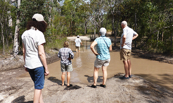
An early start was needed for the final day of the OTT as there were many waterways to be explored. We saw many campers as we drove through Canal Creek, all eager to offer advice about the best way to cross and exit the creek. Sam Creek with a sandy bottom, was quickly upon us, and again many campers here. Entering Mistake Creek, the side walls were very deep and narrow so careful wheel placement was required, but the creek crossing was quite easy. At Cannibal Creek, even the ‘easy’ entry was very steep with a deep drop off. The creek was not too deep and the start of the sandy exit was straight forward. However, the steep climb out was very soft and rutted and so a ‘pull’ was needed for one of the vehicles. The old log bridge over the Cypress Creek required careful wheel placement to ensure a safe passage over this creek. At Logan’s Creek we caught up with five vehicles and a boat trailer. Several people were in the blue grey mud hole up to their arm pits so we elected to stay on the bank and watch them. Here we chose the steep drop in followed by a short drive out with the water up to the bonnet level. The other entry was not as steep, but appeared much deeper. The exit was quite gradual and sandy. The final crossing on the OTT was Nolan’s Brook which we had heard a great deal about. When we arrived there were 11 cars queued up in front of us so we had plenty of time to plan our attack. Unfortunately we saw two of those 11 cars drown in the very deep water of the crossing. We knew we were going to need a pull once we drove the very steep entry into the deep hole at the entry point so we asked the driver of one of the successful crossers to pull our first car. With bridle on the front recovery points, a snatch strap and winch extension attached to the rear of the car that was already across, our first car gingerly slid down the steep entry then the tow vehicle pulled the floating car until it could get some sand under its wheels for traction. And out we drove! We then proceeded to pull our other two vehicles through successfully, and the car behind us so that the next group of cars had an anchor point. This crossing, as with many challenges we met on our trip, was made easier with the assistance of other helpful travellers. With Nolan’s mastered, we then popped out to the PDR and up to the Jardine Ferry to cross this mighty river on the ferry. Mutee Heads beach was our destination for the night. This beach camp was a peaceful spot after our action packed day.
Waking to the lapping waves on the wide beach front we were thankful no crocodiles had drifted in overnight. We explored the old WWII radar tower overlooking Mutee Heads then drove to the mouth of the Jardine River where it flowed into the ocean. This was a vast, wide sandy estuary, but still no crocs! Back on the PDR we stopped to view the WWII remains of a DC3 plane that crashed near Bamaga. We restocked supplies at Bamaga before heading north to the Croc Tent to gain some local insight into the Somerset Five Beaches drive. Lunch was enjoyed at Punsand Camping ground where we were to spend the next four nights. Our tents overlooked the beautiful white sandy beach which provided a perfect spot for the lovely sunsets for the following days. Once again, the ‘Achtung’ crocodiles sign prevented even the thought of a dip in the turquoise water. With hot water, showers, washing machines, a pool, a bar and restaurant this was a great northern retreat after many days out on tracks with bush and beach camps.
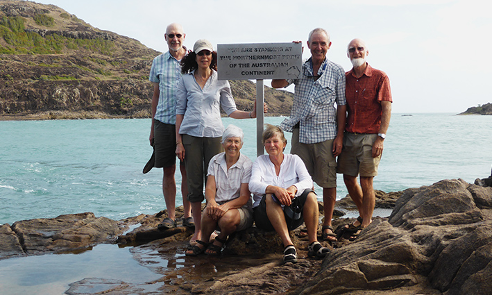
Next morning we headed off to The Tip via the 4wd Roma Flats track. The walk over the rocky headland was punctuated by rock cairns built up by fellow ‘explorers’. By 9:30 we were at The Tip, or Pajinka as it is referred to by the aborigines. We had plenty of time to photograph our momentous achievement as the wind blustered around the rocks. With York Island in the background we proudly stood clutching the sign “You are standing at the northern most point of the Australian continent”.
Many people were arriving over the headland so we moved away but helped out taking photos of other people eager to record the event. We even witnessed a marriage proposal. As crowds of people were arriving, we headed back to the beach to enjoy a cuppa and reflect on our achievement. We drove to Somerset Beach which was the sight of first white settlement in the top end back in the 1850s. The Five Beaches drive started at Fly Point, a gusty black volcanic outcrop, before we drove out along the wide hard sandy beaches, up and over rocky headlands, all the while taking in magnificent views. Facing east, it was not surprising that the beaches were very windy and littered with lots of rubbish that had been borne by the sea. We then headed back to the Croc Tent in search of any information to help us find an ‘interesting’ tree. However, we were informed that access to the tree is now completely gone but we had some fun trying to find it!
Our rest day at Punsand Bay was well appreciated by all. The following day we drove to Seisia to catch the early morning ferry to Thursday Island. Here we were met by our guide and local resident, Liberty. After a quick historical tour of the town, we drove to Green Hill Fort built in 1890s and was later used in WWII by the Australian forces. Now it houses a wonderful museum of the local military history and information about the early pearling industry of TI. We then took a short ferry ride to Horn Island where we wandered through the expansive WWII museum before we had a wonderful buffet lunch. Guided by Liberty’s wife, Vanessa, we set off to explore the WWII heritage sites that have been restored on Horn Island (Australia’s most attacked site, second to Darwin, in WWII). The huge gun with the nearby predictor shelter, the zig zag slit trenches and the soon to be further exposed American aircraft that crashed near the airport had fascinating stories passionately retold by Vanessa. Travelling back to Seisia via the two ferries, we had much to reflect on about the great importance these islands have played in defending Australia.
An early departure from Punsand Bay was called in order to avoid the long queues at the Jardine ferry we had heard about. It worked! We reached Fruit Bat Falls in time for morning tea and a swim, only the light rain deterred most of the group from the water. Driving the PDR today we encountered lots of corrugations, road works, and quite a lot of traffic, often overtaking us at great speed! The grassy open camping at Morton Telegraph Station was very welcome at the end of the day. The walk to Barramundi Hole via the bus group camping area and the little museum was interesting. Talking to the other travellers and the caretakers at MTS also enabled us to get current information on the Frenchman’s Track for the following day.
After a short drive on the PDR we found the un-signposted entry to the Frenchman’s Track. The first 12 kms were narrow with many big washouts before we reached the Wenlock River crossing. The entry was sandy and steep. Once all down we then walked the crossing to decide the best route to avoid large rocks and holes. With people situated near the spots to avoid, the vehicles easily crossed this quite deep river. The exit was long and sandy with big ruts. It wasn’t long before we were all out of our vehicles again as we met ‘oncoming vehicles’. Five cars (one towing a boat) were attempting to cross a huge mud hole from the opposite direction. Several members of their group were in the chest deep murky water planning their attack. We watched as they slowly slid their vehicles down the near vertical entry then snatched the cars out of the hole and into the gently sloping exit. They offered to use one of their cars as an anchor to pull one of our cars up the vertical exit before moving on. This camaraderie was ever present out on the tracks! With one vehicle safely up out of the mud hole we proceeded to pull the other two cars out of the muddy mire. We assisted another car over so the next group could continue also. Morning tea was late that day! Driving on to the Pascoe River, we encountered lots of deep washouts and steep gullies down the middle of the track. There was evidence of track clearing after the recent cyclones with lots of ‘go rounds’ to pass fallen trees. Our descent into the Pascoe River was very steep with big rocks. Halfway down we regrouped on a flat area as we became aware of another group at the river’s edge. Lunch was called as we watched two motor cycles and their support vehicle attempt the crossing of the fast flowing and very deep river. Having drowned one of the bikes, they then had to get it restarted before it could attempt the very steep, rugged exit. We had plenty of time to walk the river, learn from their mistakes and plan our attack! It was a slow steep rocky entry into the river. Then the course through the chest deep water had to be exactly driven. One bad jump-up on the exit route had to be filled with rocks after each vehicle scrambled over it. Carefully guiding the cars, all three made it through the Pascoe River, with one last pull for one car to get out of a deep rut. We made it through the most difficult river crossing of our trip, unscathed! The last section of Frenchman’s Track was very sandy with low scrub before we popped out to the asphalted Portlands Road. Approaching Chili Beach we saw much evidence of the two cyclones that passed through earlier in the year. Many trees were blown over or snapped in half, the foliage had been stripped from the trees and regeneration was evident. Roadworks had restored the good track into the beach. We had been forewarned about the strong easterly winds that buffet Chili Beach. Fortunately our camp sites were well protected, despite the damage to the trees and the wind was not gale force during our stay. At dusk that day, we witnessed the murmuration of thousands of metallic starlings flying overhead towards their roosting spot on the small rocky island off the beach.
Our second day at Chili Beach was spent exploring the beautiful white, wide sandy beach. We drove to the small community of Portland Roads to enjoy a delicious seafood lunch at the ‘Out of the Blue Café’. Overlooking the sheltered bay, we searched in vain for a crocodile basking in the sun or gliding through the shallow water. That evening the metallic starlings returned in their noisy rush to roost on the island for the night.
Leaving Chili Beach, we drove into the nearby aboriginal community at Lockhart River. This community is well serviced by a barge that brings in supplies from Cairns. The cyclone damage here was also very evident. We then stopped on the Portland Road at the Mt Tozer lookout, part of the Iron Range mountains. Just before the Wenlock River, we turned into the bush and found the old machinery and discarded mine shafts from the 1890s Batavia Gold fields. Once back to the PDR near the Archer River Roadhouse, we were subjected again to corrugations, road works but less traffic. We camped the night at The Bend, just short of Coen, beside the Coen River. This was a lovely sandy camp spot with great swimming opportunities.
We broke camp early and headed into Coen where we rendezvoused after making use of the local store and facilities. The PDR was asphalted out of Coen, then returned to corrugations and roadworks. Fuel was cheapest at Musgrave Roadhouse so we stopped there for morning tea and refuelled. Much of the road was asphalted to Laura so we arrived earlier than anticipated so we had lunch at the Quinkan Cultural Centre and enjoyed learning more about the indigenous people of the region. Then we set off on the start of the Old Coach Road, travelling the first 32 km to the Jowalbinna homestead. Here we met Matt Tresize, the land owner, who welcomed us onto his property. Driving on another 2 km we came to the now closed camping ground which was to be all ours for the next two nights. Once a huge camping area for visitors, the double bunk buildings, toilet and shower buildings and large kitchen and communal dining area, was now derelict, due to a flood two years ago. The flat river frontage was now home to wild cattle and agile wallabies, our neighbours for two nights. Yet another stunning bush camp setting!
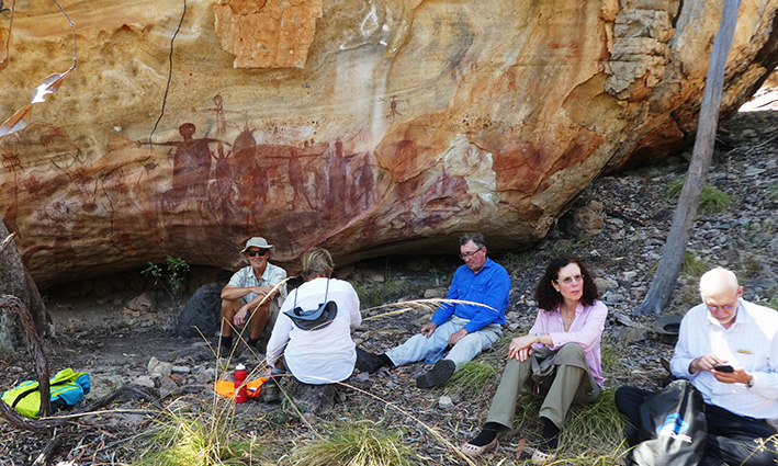
The next morning we met Matt Tresize and drove 12 km to the sandstone outcrop where we then set off on foot for the rest of the day. We visited many rock art sites, first discovered by his father in the 1960s. As a pilot, he flew over the region often and surmised their might be artwork there so he acquired the pastoral lease of the area. The area was originally explored and documented in the 1960s by white people, but the local aborigines knew nothing of the area. Much of the rock art was done in overhang areas that would have provided shelter out of the rain. We saw images of the local totem yams, men, women, kangaroos with straight horizontal tails, dingos with upturned tails, flying foxes, emus, rifle fish, eels, fresh water garfish, goannas, crocodiles, barramundi and Quinkan or spiritual figures. In places drawings were done on top of existing artwork. Hand splatters and outlines also appeared. Pantographs covered in hard ‘glaze-like’ surfaces were also seen. Seed grinding grooves were evident in large rocks. We sat in the shade of a huge wall of many, many images as we ate lunch, quite overawed by the spectacle before us.
Then we climbed right to the top of the sandstone escarpment with a view over the valley towards Laura. It too, was amazing. As we walked through the bush, Matt told of the aboriginal uses of the trees and bushes around us. His knowledge about the local indigenous people was astounding. We may have been his last walking tour of the rock art as he is considering closing down the tours and the camping area is now closed. Our day was a rare privilege. We had much to ponder that night around the campfire.
 |
The final day of our Cape York trip was to be massive. We had an early start as we headed off to Maytown via the Old Coach Road which we had heard was very, very difficult. Driving through low scrub, then climbing to the top of big grey sandstone boulders, we had great views from the top of the escarpment. After about 14 km, the track deteriorated greatly! We had very steep rocky climbs up and down into mainly dry creek beds. The rock jump ups required careful wheel placement. We met two oncoming vehicles in a very precarious spot who told us of the challenges ahead. Slowly we pushed on, having lunch and a well-earned rest on the banks of the North Palmer River. Soon after, we arrived at Enterprise Hill, the site of the Louisa Mine. There was a big battery machine and other relics of mining machinery here. Further on we visited Comet Mill and the Ida Mine. Several very deep mine shafts still remain. Maytown, the old mining township, was reached five hours driving time after leaving Jowalbinna. We walked the old stone guttered streets of the gold mining town reading the plaques on the old building sites. The reconstructed miners hut offered a brief glimpse into the life of the gold miners. |
The 79km drive along Whites Creek Road to the PDR was challenging because of the endless huge rolling hills and blind crest tops. Once on the asphalt of the PDR the last 67km was straight forward. The Mt Carbine caravan park, an old mining camp, was our final destination. Our final meal was to be at the local pub, but the cook never turned up! So we dined on fried chips cooked by the barmaid! But that’s what it is like in the Top End. You never know what is going to happen from one day to the next! As we celebrated the completion of 23 days on the tracks with no damage to vehicles and all travellers happy and safe, we agreed it had been a trip of a lifetime.
Words & photos: Shared credit.