Via the Simpson Desert and Mt Moffatt section of Carnarvon NP, 12 July - 1 August 2022
Trip Leaders: Paul and Tineke
Participants: Colin A, David and Sue, Gary, Mark and Felicity, Pete
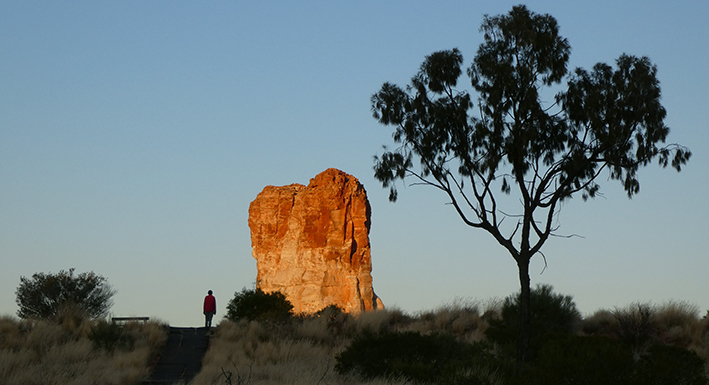
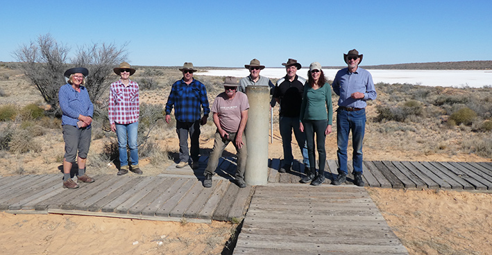
We all met outside the G’Day caravan park and after the trip briefing, we set off towards Chambers Pillar via the Maryvale Rd. Our first stop was Ewaninga rock carvings which are so sacred that their meaning was not explained. Our next stop was Titjikala where the cultural arts centre welcomed us. Colin set the pace by purchasing a painting that took his fancy. He was told that the artist would be there the next day and he would explain the work. On our way to Chambers Pillar, the lunch spot was a good place to collect some wood for our fire. This was the only place in the whole trip that the Ranger visited and checked our camping permits, while he was cleaning up the campsite. We did a lap of Chambers Pillar to see it from all angles and climbed up the stairway for a closer look. Early explorers had carved their initials into the rock in 1870. Sunset photos were obligatory.
Overnight we had some visitors from furry friends, small ones. Our peppermint spray was put to good use. We stopped again at Titjikala but the artist was absent, so we continued on to Finke for a fuel stop ($2.40/litre) except that there was no fuel! “Come back tomorrow.” We had enough fuel, so continued on our way. But the shop did have mouse traps! This part of the track was the old Ghan railway and there were many railway spikes lying on the road, to be avoided. Old Andado was our next camp, and after dinner the camp host Helen gave us the interesting and intriguing history of Molly Clark and her family’s life as we sat round the campfire. The next morning, the mouse traps were empty, including the bait. We were free to wander around this living museum, enjoy the morning tea and scones, as well as a walk to the sand dunes past Molly's grave.
At Mount Dare we topped up at $3.28/litre, before setting up camp, and availed ourselves of the dining facilities at the stubby holder filled bar. The ice-cold morning delayed our start as hot coffees and egg and bacon rolls were enjoyed for breakfast. But the good news was that Gary eventually trapped the elusive car mouse that had been enjoying his food for the last five days.

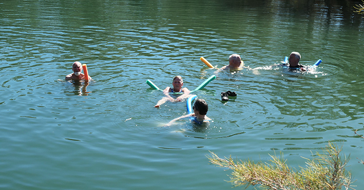
The open gibber plains and the salt lake view were the highlights on the way to the Dalhousie Station ruins in South Australia’s most northern pastoral lease. It’s almost hard to believe that the land was used to graze and breed sheep, goats, horses, camels and cattle. Other more experimental agricultural crops such as date palms and lucerne were also trialled. Noodle floats were supplied for our pre-lunch swim in the 34°C waters of Dalhousie Springs.
We continued to our first night in the desert at Purni Bore. The hot smelly water was gushing out of a pipe into a small reed filled lake. Bird life abounded.
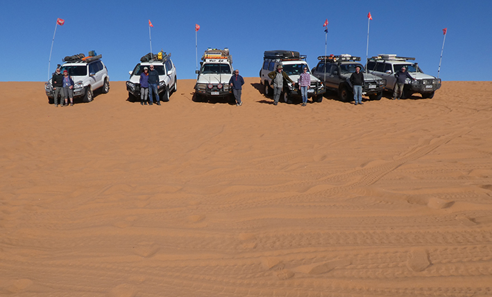
Our first real taste today of sand dunes as we travelled east on the French Line. Plenty of footprints on the track but no dingoes or camels were sighted. At the top of each sand dune, depending on how far we could see, we advised parties travelling west that we were traveling east. UHF has quite a range, so we often didn’t know how close other travellers were. Only twice did we meet another vehicle near the top – sand flags being the warning. We soon turned south to the Rig Road and the abandoned Mokari Airstrip. Morning tea stop was right next to a challenging beautiful red sand dune. Some of the boys couldn’t resist the challenge and tested their ability to climb the steepest track. None succeeded! Tyre pressures too high and we still had four more days of sand dunes ahead of us.
We continued along the Rig Road past Georges and Lynnies Junctions in search of our next overnight camp. The firewood we had collected before entering the desert park kept the cold nights at bay for a little while as we star gazed and relived some of the numerous sand dune climbs and descents, but it was soon time to escape into our warm sleeping bags and hear the occasional dingoes howling to each other.
On the way again, we looked out for suitable paddy melons for our game of desert bowls scheduled for the next day, it being a rest day. The campsite in a swale on the Knolls Track offered an ideal bowling rink and interesting dunes to explore on foot in more detail. Our morning activity included a walk over the dunes – I wonder what is over the next one. Four dunes later we saw another salt pan stretching the full length of the swale, as far as the eye could see. We were surprised at how many salt pans we crossed. Pete decided that he would be the rink designer, rule maker, scorer, judge, you name it, and we all lined up to try our hand at paddy melon bowls. Felicity was declared the winner.

During the day’s travel we sighted many changes of vegetation. Some swales were thick with gidgee trees and others just had scattered low shrubs. We saw a variety of wildflowers and birds. Near some of the salt pans there were hard limestone rocks to negotiate. Some of the more seasoned travellers in the group had not seen the Simpson Desert as green as it is now. A photo in the dry salt lake is a complete contrast to the bright red dunes.
We were surprised by the number of motorbikes on the track, the vast majority of them being on supported trips. We expected to meet more vehicles and we only saw two or three towing trailers.
The Approdinna Attora Knolls are rare and scientifically important limestone outcrops as well as being the home of the Rain Ancestor “Kuntili”. They were explored as we took a morning tea break. On the way to Poeppel Corner where SA, QLD and NT meet, the dunes became a bit more challenging, but when the tyre pressures were dropped another 2psi, it made all the difference.
Soon after joining the QAA line, we found our last campsite in the Simpson Desert. Campsite were numerous, well compacted and did not require sand pegs.
Not long after leaving the desert, the vegetation changed from gidgee to eucalyptus, and we were now in cattle country on Adria Downs Station. The Eyre Creek provided our next campsite and another place for a rest day so we could explore the mostly dry creek and enjoy the birdlife of zebra finches, budgies, galahs and corellas, white plumed honeyeaters, diamond doves and brown goshawks to name a few. Another warm campfire and Mark and Felicity cooked pancakes dripping with maple syrup and cinnamon to complete the evening.
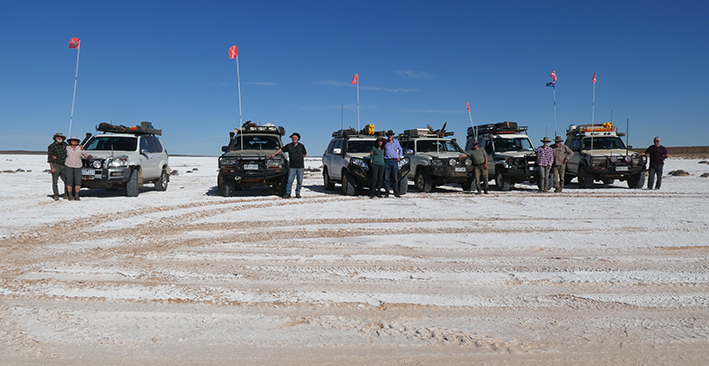
A new day and the billy was soon boiling, and tents packed up as we prepared for the last challenge – Big Red – a short drive away. As we approached Big Red, we assessed which one of the possible six routes we would choose to tackle. Some of us made the ascent on the first attempt others after two or three with some adjustments to the tyre pressures. Eventually we all arrived at the top and posed for the obligatory photo.
There was no evidence of the Big Bash music festival which had been held two weeks earlier on the eastern side of Big Red. Time to return tyres to road pressures as we proceeded to Birdsville via the rubbish tip. Everyone was keen to see what their fuel consumption was for the desert crossing, and it ranged from 86 to 129 litres for the 575km – choose your car! Five days of driving from Mount Dare, averaging 115km/day, a leisurely pace. After checking into the caravan park, camel pies and ice creams became a priority. The Birdsville Pub was the ideal place to celebrate a trouble-free successful crossing of the Simpson Desert.
On the rest day we visited one of the only three stands of acacia peuce, the rare wadi tree, the Birdsville Racecourse, the old Diamantina River crossing which was in flood, the geothermal artesian bore with the adjacent free washdown bay, the cemetery, the old Royal Crown Hotel and the old hospital. A couple of days earlier we found a mobile phone in the bush and after making a few enquiries via numbers on the phone we located the motorcycling owner on his return trip via the Madigan Line as he was known by the Caravan Park staff! Phone in the desert – modern version of needle in the haystack.
Our convoy of six cars now became four as Gary and Colin left us to travel south via Haddon and Cameron Corner. We continued to Windorah via Beetoota on the sealed and unsealed road. The campground was made of road base material and impossible to drive pegs into. Good thing it was a still night. We can recommend the Windorah Pub as they put on an exceptional roast pork meal for us. We left Windorah via the 12-kilometre nature drive where we saw many species of native trees and shrubs and a few birds. At the end of the drive, we came across the junction of Coopers Creek and the Warrego Way. We made our way to Stonehenge where we stopped for lunch. Continuing north we turned off on a lonely but smooth gravel road heading towards Isisford. On this road we saw many bearded dragons, emus and brolgas. After booking a campsite at the council chambers we made our way to the Oma Waterhole campsite where there were hundreds of campers waiting for the annual yellowbelly fishing competition to start a few days later.
Blackall was the first big town with a supermarket to replenish our supplies, before continuing to Tambo. Chicken racing is the sport of choice here – the pub owner uses this daily unique event to raise funds for the Royal Flying Doctor Service. He had nine appropriately coloured and named ‘racing’ hens. These ‘ladies’ chase a remote-controlled bucket of food around a circuit – a sight to see!
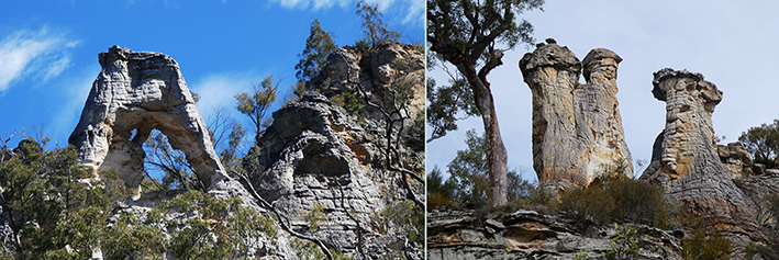
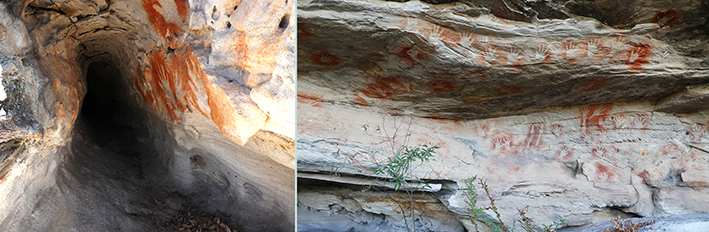
Sadly, Mark and Felicity needed some time to recover, so three vehicles continued east in search of Mount Moffatt in the western section of Carnarvon National Park. The track was a bit circuitous and looked OK on Google maps, but we ended up, to put it plainly, ‘lost’. It was getting late so we set up camp on the side of the road, after deciding that we would have to return about 150km to more defined roads. It turned out we were on private property, and we gave the returning station manager a bit of a shock when he saw us at about 8.30pm. After explaining our predicament, he relaxed and offered to show us the way in the morning. Just 18km to our destination. Black soil plain, so some mud to be expected and a river crossing, but it turned out to be an easy drive with great scenery. And it still left us time to explore the amazing Mount Moffatt sandstone formations of the Marlong Arch, aboriginal burial tubes, Lots Wife a sandstone pillar, the Kookaburra Cave with its rock art and Marlong Plain, an open grass area.

We set up camp at the West Branch campsite before exploring the High Country Drive. Low range was engaged for the steep climbs and wet and muddy patches to access the viewpoints, the mahogany forest and the head of the Carnarvon Creek.
We left a dish of water out overnight and the ice was 10mm thick in the morning. On our last full day at Mt Moffatt, we drove south past the Ranger Station for an enjoyable walk to the Looking Glass a wind eroded hole in the pillar, the Tombs with its rock art and burial tubes, the Chimneys (three adjacent pillars) and Cathedral Rock, a precipitous sandstone bluff.
Back to camp via the Dargonelly Rock Hole campsite, for a lazy afternoon and hot date scones from the camp oven.
On our way to Judds Lagoon near Yuleba via Injune and Roma, Pete decided that it was time for him to head south, so we were now a ‘convoy’ of two vehicles. Judds Lagoon was a bird lovers paradise.
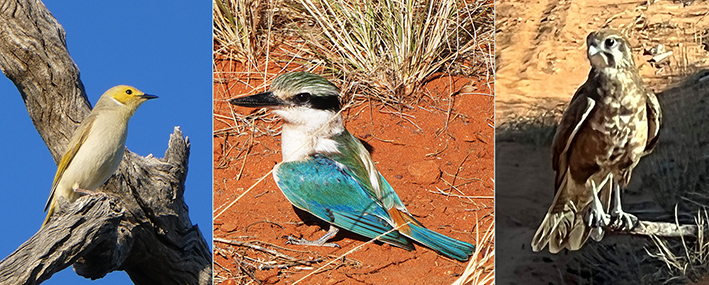
White Plumed Honeyeater, Red-backed Kingfisher, Brown Falcon

Red Winged Parrot, Grey Falcon, Brown Goshawk
A night in Toowoomba and a motorway trip via Brisbane had us in Mullumbimby for the last leg of the trip to Cape Byron. It was a very popular spot with its outstanding lighthouse and the short walk to the most eastern point of mainland Australia. The trip leaders had now completed all the extreme north, south, east and west points of Australia, a long-held ambition.
Total distance covered: 3560km
Text and photos: Paul, based on input from all participants.